World
Earth experienced its warmest April on record as US prepares for brutal summer heat

Earth has just experienced its 11th straight warmest month on record — a preview of the brutal temperatures forecast for the summer, according to scientists.
Last month continued a relentless stretch of record-breaking global temperatures for the planet after it measured as the warmest April on record, according to a monthly climate report by Copernicus, Europe’s climate change service, released on Tuesday.
April 2024 saw an average surface air temperature of 15.03 degrees Celsius, or 59.05 degrees Fahrenheit, the report found. The temperature measured at 1.21 degrees Fahrenheit above the 1991 to 2020 average for April, according to the report.
May 2023 through April 2024 was the warmest 12-month stretch on record with a global average temperature of 2.90 degrees Fahrenheit above the 1850 to 1900 pre-industrial average, the report found.
A ‘Heat Kills’ sign is posted as visitors walk nearby, April 23, 2024, in Death Valley National Park, Calif.
Mario Tama/Getty Images
The Paris Agreement goals aim to limit global warming to 1.5 degrees Celsius higher than pre-industrial levels.
Global sea surface temperatures across a majority of the world’s oceans remained at unusually high levels in April 2024, according to the report.
The average global sea surface temperature for April for the majority of the world’s oceans was 21.04 degrees Celsius, or 69.87 degrees Fahrenheit — the highest value on record for the month of April.
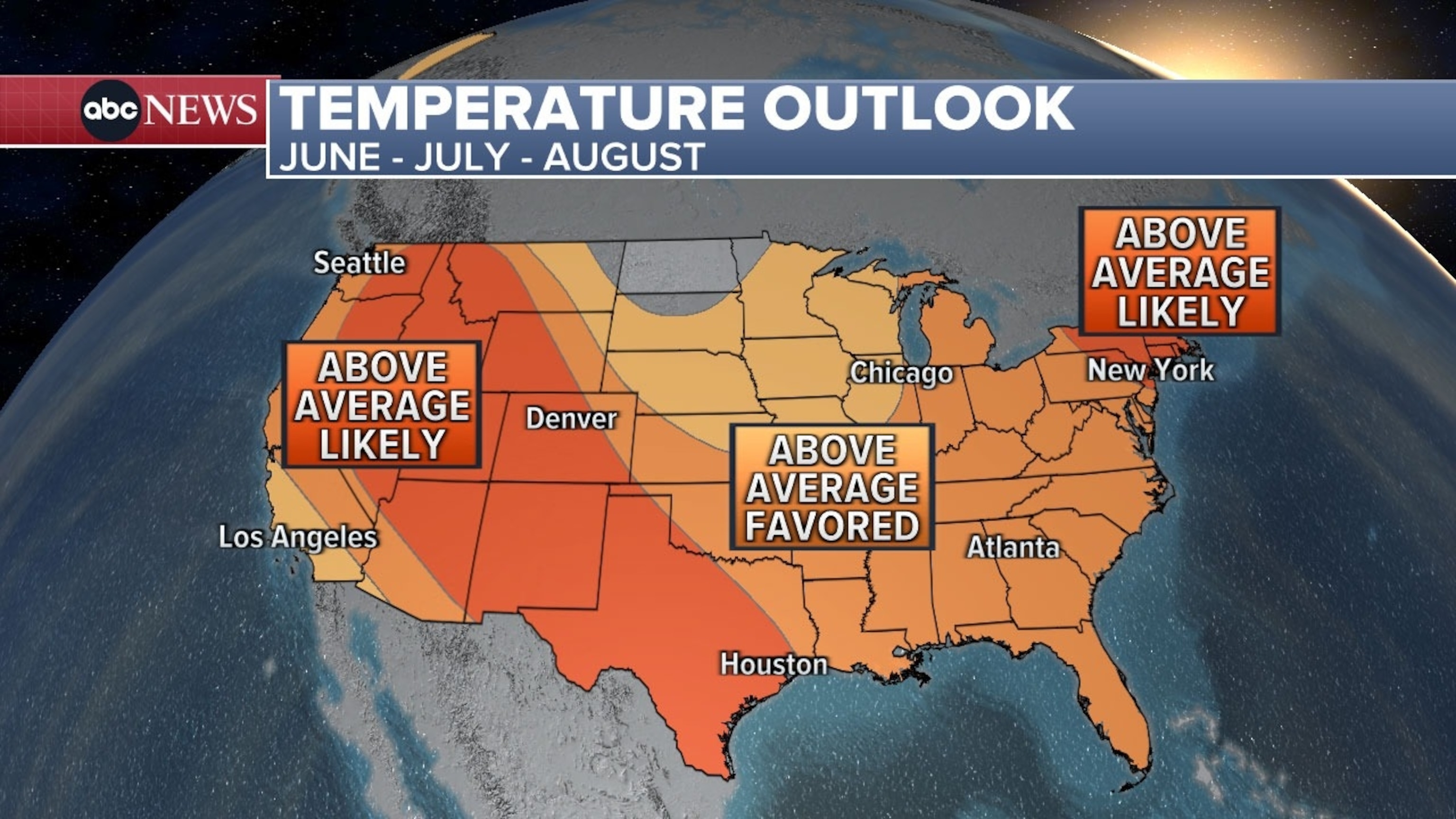
The report comes as the U.S. prepares for brutal heat this summer. The latest National Oceanic and Atmospheric Administration seasonal outlook for the summer months, released in April, shows above average temperatures favored for much of the country between June and August.

Thai dancers drink cold beverages and cool down from the heat with an electric fan as they take a break from a worshipping god performance, during a heatwave at the Erawan Shrine in Bangkok, Thailand, April 30, 2024.
Rungroj Yongrit/EPA/Shutterstock
The first heat wave of the year is already underway in parts of the South, with blistering temperatures expected from Texas to Florida throughout much of the week.
The last time Earth recorded a colder than average year was in 1976 — 48 years ago — according to NOAA.
El Niño conditions over the equatorial eastern Pacific and greenhouse gas emissions have both contributed to the relentless stretch of new global temperature records. El Niño peaked at the beginning of the year and the sea surface temperatures in the eastern tropical Pacific are now going back towards neutral conditions.
While the El Niño conditions are fading, the warming effects are expected to linger for months, according to scientists.

The latest summer temperature outlook from NOAA’s Climate Prediction Center shows that above average temperatures are favored across most of the contiguous U.S. between June and August 2024.
ABC News
Several regions around the planet are expected to experience record-breaking average surface air temperatures through the summer as a result of heating influence from the El Niño pattern, according to a study published in Scientific Reports in February.
This increases the odds of more above average and record-breaking global land and ocean temperatures in the near future.
Such a lengthy stretch of monthly global temperatures records is unusual, but a similar stretch was documented in 2015 and 2016, also El Niño years, records show.

Women dip their feet in the cool fountain at the World War II Memorial on a possible record setting heat day in Washington, D.C., April 29, 2024.
Kevin Lamarque/Reuters
Human-amplified global warming is continuing to exacerbate normal climate variations, Carlo Buontempo, director of the Copernicus Climate Change Service, said in a statement.
“Whilst temperature variations associated with natural cycles like El Niño come and go, the extra energy trapped into the ocean and the atmosphere by increasing concentrations of greenhouse gasses will keep pushing the global temperature towards new records,” Buontempo said.
The latest forecasts show the current El Niño event officially ending in the coming weeks, transitioning to neutral conditions. La Niña will likely return this summer.


