World
The destructive power of Hurricane Milton in 3 images

 Nasa
NasaThese images show where Hurricane Milton’s power came from, and some of the risks faced by those in its path.
Milton arrives less than two weeks after Hurricane Helene devastated the Gulf Coast and killed at least 225 people in Florida, Georgia, South Carolina, Tennessee, Virginia and North Carolina.

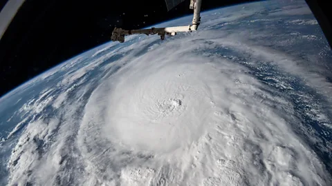
 Nasa Earth Observatory
A hurricane forms when a weather disturbance, like a thunderstorm, pulls in warm surface air from all directions. Seawater evaporates and is dragged upwards by converging winds. As it rises, the water vapour cools and condenses into clouds and rain – and more warm moist air spirals up from the surface to replace it. And warmer oceans, mean more extreme hurricanes, experts warn.
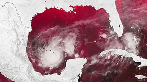
 Nasa Earth Observatory/ Michala Garrison
Hurricane Milton formed in the Gulf of Mexico at the same time that two other large hurricanes were churning above the Atlantic. Hurricane Leslie, in the bottom-right hand corner of the image above, and Hurricane Kirk, towards the top-right, formed a trio of storms on 6 October as Hurricane Milton was gaining strength.
It is unusual to see three storms forming at once this late in the season, meteorologist Philip Klotzbach of Colorado State University pointed out on X, formerly known as Twitter. In fact, it is the first time this number of hurricanes has been seen simultaneously across the Atlantic in the month of October since satellite records began in 1966.
“The ocean temperature in the Gulf of Mexico is at or near record levels right now and this provides hurricanes over that region with plenty of ‘fuel’,” says Joel Hirschi, associate head of marine systems modelling at the National Oceanography Centre (NOC).
“A warmer climate means warmer seas,” says Hirschi. “There is growing evidence that the time needed for tropical cyclones to intensify to powerful category four or five storms is reducing as climate warms. The rapid intensifications we have seen in the Atlantic for Beryl, Helene and now Milton follow that pattern.”
 Getty Images
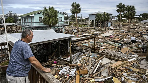
While the powerful winds and gusts that Milton is expected to bring to Florida will be damaging, it is also creating conditions that are likely to see tornadoes develop across central and southern Florida, according to the National Weather Service. Flooding is also more likely as soil moisture levels in many parts of Florida remain following heavy rainfall brought by Helene, which means the ground is not able to absorb as much water.
But perhaps the greatest threat to life and property will be the destructive storm surge that Milton is expected bring with it.
Widespread flooding and strong wind gusts triggered by Hurricane Helene caused billions of dollars in property damage, and blew down trees and power lines in an area stretching from the Gulf Coast to the North Carolina mountains.
Emergency workers are racing to clean up the storm debris from Helene, so that the pieces do not become projectiles when Milton hits. Florida’s Department of Transportation removed over 1,300 truckloads of debris on Monday and Tuesday, Governor Ron DeSantis said in a press conference.
“The more debris we can get picked up, the less damage that is going to happen, whether that is floating in the Gulf of Mexico, whether it’s projectiles that go into other buildings,” DeSantis said.

“Reckless”: North Korea Slams US-Led Criticism Of Involvement In Ukraine

World Bank approves $2 billion package for Ukraine with US loan backing

US Federal Reserve cuts interest rate by 25 basis points in key FOMC meet – Times of India

Top Online Casino Game Providers | Suffolk Gazette

US Reports First Severe Infection Of Bird Flu In A Human

Unpacking Trump’s latest broadside about Canada as a ’51st state’ | CBC News

Looking to retire in Georgia? These 3 cities are best according to U.S. News & World Report

US State Of Indiana Carries Out First Execution In 15 Years

‘World’s first’ grid-scale nuclear fusion power plant announced in the US in another step for the futuristic energy | CNN
